“Maps are like milk: their information is perishable, and it is wise to check the date.”
“Like guns and crosses, maps can be good or bad, depending on who’s holding them, who they’re aimed at, how they’re used, and why"
Mark Monmoneir, Syracuse University of Geography
Author of How to Lie with Maps
Take a few minutes to explore this mapping tool which helps show the problems with the Mercator map. What happens when you type in Russia and move that country south to the equator? What happens when you type in Dem. Rep. Congo and move it north over Europe? What happens when you move Brasil over the United States?
How do the maps you look at shape the way you see the world?
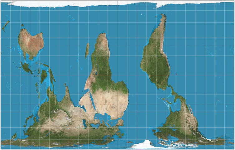
South-up Peters projection.Daniel R. Strebe, CC BY-SASouth Up?
North is up, right? Only by convention. There’s no scientific reason
why north is any more up than south. Equally, we could do east-up,
west-up or any other compass bearing. Purposefully reversing the typical
way world maps are drawn has a similar political effect to using the
Peters projection, putting more developing countries in the generally
poorer southern hemisphere at the top of the map and so giving them
greater significance.
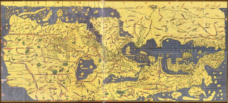
But some of the first known world mapsput south at the top as a matter of course. For example, in 1154 Arab
geographer Muhammad al-Idrisi drew a south-up map of Europe, Asia and
northern Africa for his book the Tabula Rogeriana. The Arabian Peninsula
can be seen in the center of the map but, of course, pointing upwards
rather than the more familiar downwards.
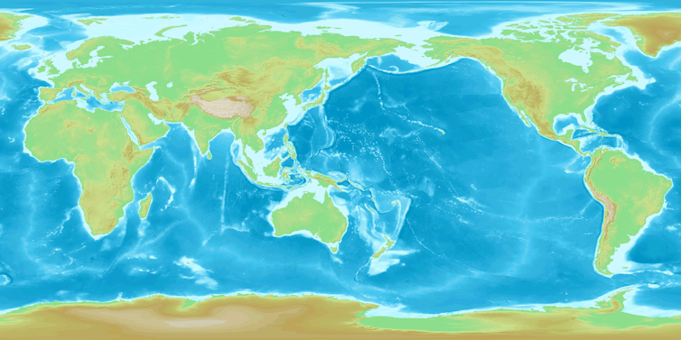
Another convention of world maps is that they are centered on the
prime meridian, or zero degrees longitude (east-west). But this is
scientifically arbitrary, deriving from the location of the Royal
Observatory in Greenwich, London. The result is that Europe (although
also Africa) is in the center of the conventional world map – a rather
colonial perspective.
The familiar meridian-centered map conveniently places the map edges
down the middle of the Pacific Ocean so no continent is chopped in two.
But maps centered on the Pacific Ocean also work well because the edges
of the map conveniently run down the middle of the Atlantic. This places
east Asia in a more prominent position and pushes Europe to the edge.
Much of Oceania and Asia uses Pacific-centered maps. (American-centered
maps are also in use, but these have the unfortunate consequence of
partitioning Asia to either side of the map.)
Our meridian-centered view of the world shapes how we refer to world
regions. “Far East”, for example, implies far from Greenwich, London.
Seeing Europe on the left of a map and the Americas on the right can
seem counter-intuitive, but it is just as correct as any other arbitrary
chop point. The world is, after all, round.
All the projections we’ve discussed so far tend to put one continent
in the middle of the map, giving it greater prominence over the others.
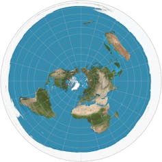
An alternative is to place the North Pole in the centre. It is strangely
disorienting to gaze on the world from a polar perspective. The lower
hemisphere should be hidden from view by the curve of the Earth because
you can only see half a sphere at a time.
But on the azimuthal polar projection from the north, the southern
hemisphere has been pulled into view on the page, with the consequence
that Antarctica centrifuges into a doughnut around the edge of the
circular map. This highlights the disadvantage of the projection as it
distorts both the area and shape of landmasses, but distances from the
North Pole are accurate in all directions, with those further from the
centre becoming more enlarged on their east-west axis.
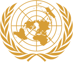
UN logo.United Nations
This “azimuthal” polar projection is depicted on the United Nations flag. North America was prominent on the initial 1945 UN flag
(which had the longitude line 90 degrees west pointing upwards). The
following year, the map on the flag was reoriented to be more neutral by
having the international date line (180 degrees east, lying in the
middle of the Pacific Ocean) pointing upwards. The map stops at latitude
60 degrees south, meaning Antarctica does not appear.
Credit to Donald Houston from the University of Portsmouth for this article.
This week you should continue working on your regional maps and areas of interest for Unit 1.
Read: Prisoners of Geography chapters 3 and 4
Check the news: Find a recent news or magazine article (within
the last 90 days) about one of the countries we are studying in unit 1.
In the comments of this post write a 2-3 sentence synopsis of the
article and another 2-3 sentences on why you think the story was
interesting or important. Provide the link to the article in your
comment. You must choose a story on a different subject or from the
opposing perspective of one posted by your classmates.
It includes the study of our planet and of occurrences in nature.
Geography
consists of the study of our planet, its climatic conditions, the
various landforms on Earth, and the different natural occurrences. It
includes the spatial analysis of human and natural phenomena, the
exploration of earth sciences, and the study of the relationship between
nature and human life. The study of geography includes the analysis of
social, economic, and environmental processes that affect nature.
It involves the study of people.
The
geography of a region affects the lifestyle of its inhabitants. The
geographical conditions of a region influence its culture. They have a
deep impact on the social and cultural norms of people. The geography of
a region has a direct effect on the art forms, the literature, the food
habits, and the celebrations and traditions of the people that inhabit
it. The study of geography lets us understand the distribution of people
around the world and the differences in their ways of living.
It includes the study of natural resources.
The natural wealth of a region owes its existence to the region's
geographical conditions. The geographical location of a region
influences its climate, which in turn influences the life forms that can
thrive in that region. Why does oil come from Saudi Arabia? Why are
China and India the largest producers of rice? Why do camels populate
the African terrains and polar bears inhabit the Arctic? Why is the
deciduous forest biome in parts of America, Asia, Europe, Africa, and
Australia? Why are rainforests found in the equatorial regions? It is
all because of the diverse geographical conditions around the world.
Thus, the study of geography answers several interesting questions about
the availability and distribution of resources and life forms.
It is key to development.
The
geological features vary across different parts of the globe. Why are
certain regions more prone to earthquakes than the others? Why some
regions experience snowfall while others don't? What are the types of
soil found in various regions? The answers to such questions and the
knowledge of landforms and altitudes is included in geology, a field
that is closely linked with geography. Its study helps us know the
natural disasters a region is prone to, thereby helping us take the
required preventive measures. It is of help to man in planning the
building of dams and electricity projects. It is of use in planning the
development of businesses and trade.
It helps us visualize the world.
The
study of geography includes understanding the locations of various
territories and countries. It includes studying the organization of
landmasses and water bodies across the globe. Maps, an important part of
the study of geography, help us locate places on the globe. Their study
helps us form a mental image of the distances and locations of various
regions on the planet. As geography
helps us gauge distances and locate places on Earth, it helps improve
our navigation skills.
It helps us appreciate life.
Studying geography helps us appreciate the diversity in life forms. It exposes us to various ecology issues
and environmental concerns. It helps us understand how nature
influences life. It lets us know how cultures take shape. It enables us
to know how civilizations are born. It helps us understand the
interaction between natural components and human beings.
***
HOME WORK
This week you should familiarize yourself with the syllabus and spend the majority of your time working through the Unit 1 blog post, familiarize yourself with the countries, think about what country or region will be the focus of your project and what you would like to do. At the top of the blog you will find a "Project Ideas" page to help you get started. You are not limited to these ideas! Feel free to design your own project.
Read: Prisoners of Geography the introduction through chapter 2. (67 pages) Before you read, check out the background notes below.
Background notes:
The following are mentioned in this week's reading. Take a few minutes to learn more about them.
Check the news: Find a recent news or magazine article (within the last 90 days) about one of the countries we are studying in unit 1. In the comments of this post write a 2-3 sentence synopsis of the article and another 2-3 sentences on why you think the story was interesting or important. Provide the link to the article in your comment. You must choose a story on a different subject or from the opposing perspective of one posted by your classmates.

